

 TARRANT COUNTY, TX

 Tarrant County Archives
City of Fort Worth Planning Department Collection

Building site for Tarrant County Convention Center, negative, circa 1965
HISTORICAL NOTE
The City of Fort Worth Planning Division, formerly the Planning Department, provides comprehensive, long-range planning for the growth and development of the city.
SCOPE AND CONTENTS
The City of Fort Worth Planning Department Collection primarily contains photographs and negatives, dating from 1957 to 1976, of various areas of Fort Worth including the Central Business District, Cultural District, downtown, Fairmount-Southside Historic District, Montgomery Street, Ryan Place, and the future site of the Tarrant County Convention Center (now Fort Worth Convention Center).
NOTE: Some images taken by commercial photographers have restricted access. They may be viewed in person at the Archives but may not be reproduced without permission from the photographers' estates. Click here to see our Image Use Agreement for more information.
Photographs
(48) monochromatic photographs, 1957-1958; undated
- Aerial view of West Freeway looking east from Summit Avenue, by Squire Haskins, late 1950s; undated (restricted - requires permission)
- Aerial views of downtown Fort Worth, by Skeet Richardson, 1957-1958 (restricted - requires permission)
- Aerial views of Henderson Street, by Skeet Richardson, December 18; 1957 (restricted - requires permission)
- Aerial views of downtown Fort Worth, by Don Wallace, Incorporated, 1957 (restricted - requires permission)
- Downtown Fort Worth street scenes, by Don Wallace, Incorporated, 1957 (restricted - requires permission)
(293) monochromatic photographs and (299) black and white negatives, circa 1965
- Unidentified airport - possibly Meacham Field or Spinks Airport
- Fort Worth Central Business District
- Harris Methodist Hospital area
- Lancaster Avenue to 9th Street, Jones Street to Jennings Avenue, and site of Tarrant County Convention Center (now Fort Worth Convention Center)
- Throckmorton Street
- Fort Worth residential area
- Berry Street area near Texas Christian University
- Elizabeth Boulevard, Chase Court, and Ryan Addition
- Fairmount-Southside Historic District
- Seminary South Shopping Center
- St. Stephen Presbyterian Church
- Unidentified people
- 1300-2700 Montgomery Street
- Calmont Avenue, Camp Bowie Boulevard, Crockett Street, Tulsa Way, South University Drive, West Vickery Street, West Freeway, and other unidentified street views
- Fort Worth Cultural District
- East Berry Street, West Berry Street, Benbrook Boulevard, West Cantey Avenue, Forest Park Boulevard, McCart Avenue, Park Hill Drive, Seminary Drive, University Drive, and other unidentified street views
Ryan Place Addition Houses, (717) monochromatic photographs, circa 1965
- Fifth Avenue: 2260-3013 and unidentified addresses
- Sixth Avenue: 2411-3005 and unidentified addresses
- College Avenue: 2401-2530 and unidentified addresses
- Elizabeth Boulevard: 1001-1604 and unidentified addresses
- Lipscomb Street: 2018-2518
- Ryan Place Drive: 2416-3035
- South Adams Street: 2417-2709
- Willing Avenue: 2300-3038 and unidentified addresses
Publications
- Fort Worth Citywide Historic Preservation Plan, prepared for the City of Fort Worth by Looney Ricks Kiss, Urban Prospects; Marcel Quimby, Architecture/Preservation; Pavlik and Associates; Christopher Bowers; July 8, 2003.
- Eight Decades of School Construction: Historic Resources of the Fort Worth Independent School District, 1892-1961, prepared by the City of Fort Worth with consultant Susan Allen Kline, September 2003.
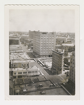
Bird's eye view of Flatiron and Southwestern Bell Telephone Company buildings, photograph, undated
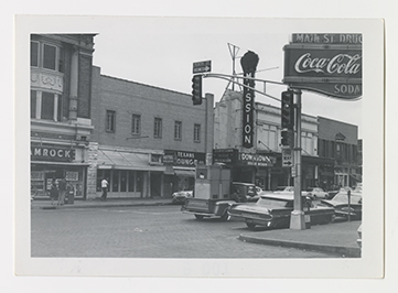
Main and Eleventh Streets, before demolition for Tarrant County Convention Center, photograph, circa 1965
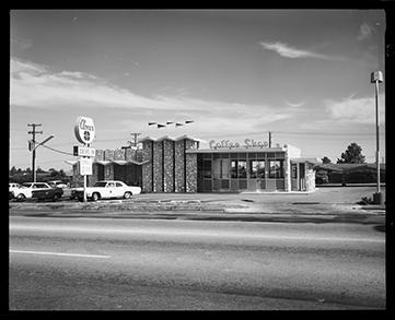
Street view of Clover Drive In, negative, circa 1965
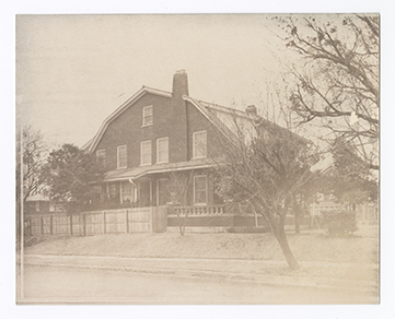
Side view of 2530 College Avenue (James-Fujita House) from West Robert Street, photograph, circa 1965